Image

The Transgrancanria Advanced 2017

The Transgrancanaria Advanced is a 82 kilometres run that covers 4.300 metres of positive elevation gain on Gran Canaria in Spain. I spend several months preparing for this event by running hundreds of kilometres up and down the west coast of Sweden. Zick-zacking around ice blocks stranded at the beach became my early morning routine. But all the training paid off and I felt pretty confident about my gaol in finishing the race below twelve hours. So I hopped on a plane to Germany from where I continued my journey to  Las Palmas de Gran Canaria with some friends.

20170215_transgrancanaria_3.JPG

Ice block at the beach on the west coast of Sweden.

We arrived one week before the Transgrancanaria to give us some rest and acclimatise to the weather. The seconds day after arrival, we headed out for a short run to check out some local trails. And then it happened. I twisted my ankle and it swell pretty bad. Starting at the Transgrancanaria Advanced was in doubt. Follow my friends advise, who is a physiotherapist,  I started several sessions of icing and heating in combination with special mobilising exercises daily. The swelling went down and I took a compromise: I was going to hike the race and drop out as soon as I feel pain.

20170225_transgrancanaria_1.JPG

Roque Nublo on Gran Canaria in Spain.

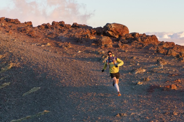
A few days later, the Transgrancanaria Advanced started in Fontanales at 7am. The atmosphere at the starting line was amazing. Nothing I had ever seen before.  Heading off through the narrow streets, lots of people alongside cheered as I disappeared with the other runners into the dawn. Every 10 to 15 kilometres, my friends check up on me to see how my ankle is doing. Surprisingly, it went pretty well. I kept going following the course passed Roque Nublo all the way to the highest point at Pico de las Nieves. From there, I could even see the neighbouring island Teneriffa with its 3,718 metres high volcano. But then it was time to drop out to give my ankle some rest. Despite all the time and effort I put into training for this race, I did not make it to the finish line. That made me feel pretty sad, but there was nothing I could do about it. Now, I am rehabilitating my ankle’s mobility and strength and cannot wait for my next upcoming race.

20170225_transgrancanaria_2.JPG

Teneriffa with its 3,718 metres high volcano in the distance. 


Image

Running on Mt. Etna

In October 2016, my personal running season came to a successful end. Back in Sweden,  long training sessions along the icy-cold beach at the coastline awaited me. How was I supposed to stay motivated to go for training runs before breakfast? That is when a friend asked if I want to run on Mt. Etna in December. The idea was to plan an ambitious project that keeps us pushing during the dark winter hours. After some research, we picked a route from the sea all the way to the summit; an estimated 30 kilometres distance with an elevation gain of 3,500 metres. It was the perfect challenge and we decided to give it a try. So we booked flights to Italy, made sure we were properly acclimatised, and had enough rest prior to the run.

20170104_sicily_trail_running_ROBERT_0094.JPG

When checking the weather the night before the challenge, our plans started to fall apart. The temperature on the summit was going to drop down to -20º Celsius. Reaching the top was not our main objective anymore. Running above 2,500 metres was going to be extremely difficult for us. Snow and ice dominated the upper part of Mt. Etna. Back to the map, we sketched out a new route until late that night. Early next day, we started somewhere outside of Catania. The course went only uphill from there. First, we had to tackle some 500 metres of elevation gain on technical terrain.  Then, the rocky trail turned into an icy ridge. Easy trail running became strenuous climbing. It took hours to cover short distances. We faced the truth and abandoned our project midway. Instead of climbing further up, we finished at the Rifugio Giovanni Sapienza. Over a cup of coffee, we enjoyed the spectacular sunset before heading down to Catania by car. We failed but I promise to come back Mt. Enta!

Image

Climbing Lobouche East Peak

After climbing Island Peak, I felt very confident about summiting Lobouche East Peak. The hike from Island Peak Base Camp to Lobouche High Camp gave me some time to recover from the strenuous climb. Earlier than expected, our team arrived at camp and we started to set up the tents when the weather turned its back on us. It started to snow so that we went inside our sleeping bags and did not leave them until the middle of the following night. The weather did not change, but we agreed to give it a try. Getting to crampon point was more difficult than on Island Peak. The hike was shorter, but low visibility gave us a hard time finding the way. From there, we continued until we reached our next big objective. A 400 metres high face leading all the way to the summit. Being one of the first teams to climb Lobouche East Peak in autumn 2016, no ropes had been fixed yet. We analysed the final stretch and decided to keep to the right side due to the risk of avalanches. Pema took the lead and I followed him wheezing through the thin air. It was tough but more enjoyable than the climb on Island Peak. When we arrived at the summit, I felt extremely exhausted. All distant peaks were lulled in clouds; Everest and Lhotse remained hidden. However, experiencing the Nepalese Himalayas in perspective was totally worth the journey despite all the pain and suffering.

Image

The Beauty of Island Peak

In the middle of the night, I wake up to start my adventure for climbing Island Peak. My body is shivering and my head is hurting, but I knew that it will get better as soon as I start moving. I force myself to drink some tea and eat some porridge before I go off into the darkness, following the poorly lit spot of my head torch. After some hours of strenuous hiking and easy climbing, I reach the crampon point. It is time for a short break and to rope up. I am feeling strong and am motivated. As we continue our way up, the sun is rising and colours all surrounding peaks in bright red. I come to believe that I can climb the final 200 metres of steep snow and ice within less than half an hour to see the sun crossing the horizon. Soon, I start to realise that it is far fetched. Every step up the mountain takes a huge effort. Cold air is painfully filling my lungs with every breath. Two hours later, I find myself on top of Island Peak (6,189 m). Sunrise is long gone. The view is amazing though. Right in front of me, the north face of Lhotse (8,516 m) is breaking through the clouds. All pain and suffering is forgotten. A truly impressive mountainscape.

Image

Northern Vietnam

20150808_vietnam_backpacking_0229-2

Sun setting between towering limestone karsts and green fields.

After a few days in Phong Nha, I continue my journey through the rest of Vietnam. Time is running short if I want to follow up on my plan to loop the Tonkinese Alps in the northwestern part of the country. Early in the morning, I am tying my backpack down on the motorbike rack and drive as far as I possibly can; 450 kilometres of dirt roads in 11 hours of heat. Definitely the longest stretch I have been driving in one single day on my journey so far. Occasionally, I stop for a quick Vietnamese coffee and a delicious Vietnamese Bánh Mì. About 100 kilometres before Cam Thuy, I cannot resists to stop and watch the sun setting between towering limestone karsts surrounded by green fields.

Continue reading

Image

Central Vietnam

20150724_vietnam_backpacking_0045

Traffic in Ho Chi Minh City

I am about to start my motorbike adventure in Ho Chi Minh City right after sunrise. A free breakfast at the hostel causes a changes of plans though. I end up in the middle of the morning rush hour. Constantly, I need to stop to check the map. One thing is for sure, Ho Chi Minh City is huge and definitely not the right place to learn how to drive a motorbike! Finally, I leave Ho Chi Minh City and am hitting the highway to Bà Rịa. The locals are really interested in my trip and keep approaching me while driving for a small chat. Several times, I am stopping because those conversations get too intense to keep driving. One local Vietnamese is even so kind and invites me for lunch.

Continue reading

Image

The Mekong Delta 

DSC_3606

Bus ride to Can Tho.

I continue my adventure and finally cross the border into Vietnam.  Apparently,  some people did not do their research and were send back to Cambodia at the immigration office, because they did not organise a visa before. On the bus ride to Can Tho, I come to realise that traffic in Vietnam is insane! Motorbikes everywhere and the bus driver is tooting the horn constantly. There seems to be one traffic rule only: busses over motor bikes! Eventually, I arrive in Can Tho at 10pm; four hours later than scheduled. Too tired to look for an accommodation myself, I join a Frenchman for a homestay after having some dinner in the street. The best decision I made this day! Continue reading

Image

Cambodia

Crossing into Cambodia from Nong Nok Khiene to Trapeang Kriel is an adventure itself. It all starts at the bus station in Don Det. A well dressed man from the bus company offers you help with immigration, handing out  the required papers and asks you to give him your passport and the visa fee of $40. $10 more than the fee according to the German Department of Foreign Affairs. Questioning the extra costs, the $10 are broken down as follows: $30 visa fee, $2 stamp fee in Laos, $3 medical check, and $5 stamp fee in Cambodia. Unlike most other travellers, I am not handing out my passport. After a short discussion making the point that the bus is not waiting for me at the border, he wanders away with about 50 passports under his arm.

Continue reading

Image

Southern Laos

Motor biking around Vang Vieng.

Motor biking around Vang Vieng.

After Luang Prabang, I am moving on to Vang Viang on the Nam Song river with mixed feelings. Apart from the beautiful karst hill landscape, Vang Viang was known as a party town for tubing until about 30 tourists died, drowning or diving head first into rocks (The Guardian). To put an end to this, the government decided to shut down all bars along the river selling cheap alcohol and offering rope swings and zip lines in mid 2012. However, the surrounding area is beautiful and I decided to take a motorbike off the beaten tracks. At nighttime, bars give out free rice schnapps, sell laughing gas and offer beer pong contests. Korean tourist are everywhere in town due to a Korean reality show taking place at the Blue Lagoon. I like the place though.

Continue reading

Image

Northern Laos

Bus ride in Laos.

Bus ride in Laos.

After crossing the border from Thailand to Laos, I jump on board a bus full of beds. These beds are not designed for Europeans and rather small. My assigned bed is also broken. Cramped into my uncomfortable bed, I am starring out the tiny window and see miles of dense jungle while the bus crawls up the hills in first gear. The scenery is occasionally interrupted by trucks, fully loaded with cattle, overtaking the bus. I am talking to the other backpackers, but all of them seem to travel to Luang Prabang and leave me wondering what to expect from Luang Namtha.

Continue reading